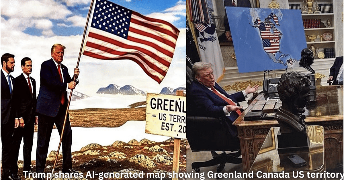
Trump shares AI-generated map showing Greenland Canada US territory sparks global buzz. President Donald Trump posted this striking image on Truth Social, claiming Greenland and Canada as part of the US.
This event shows how AI-generated images blend tech with politics in new ways. It affects AI users, leaders, and everyday people curious about tech’s role in big talks. The article ahead breaks down the post, reactions, and what it means for AI visuals now.
Key Highlights
- Trump shared the AI-generated map on Truth Social on January 19, 2026.
- The map shows Greenland, Canada, and Venezuela under US control with stars on flags.
- Images include VP JD Vance in Greenland and Marco Rubio in Canada.
- Trump calls it a “beautiful map” tied to national security needs.
- Reactions mix shock, laughs, and debate on AI deepfakes in politics.
- Greenland leaders call it “not normal” while Canada stays quiet.
Trump Shares AI-Generated Map Showing Greenland Canada US Territory: Full Story
President Trump kicked off the week with a post that blends AI tools and bold ideas. On Truth Social, he shared a colorful map where the US flag waves over huge new lands. Greenland sits as a key piece, with Canada marked as the 51st state. Even Venezuela joins the mix. The caption reads simple: “This is a beautiful map.”
The images go further. One shows VP JD Vance standing proud in snowy Greenland under the stars and stripes. Another has Marco Rubio planting the flag in Canada. These AI-generated images look real at first glance, thanks to tools like Midjourney or Grok’s image features. Trump ties it to real talks – he wants Greenland for security against China and Russia in the Arctic. Canada gets linked to trade fixes and border strength.
Why now? With Arctic ice melting, bases there matter more. Trump pushed for Greenland buy in 2019, and talks heat up again in 2026. The post comes days after Davos chats on global maps and power shifts. AI makes sharing these visions fast and viral.
How the AI-Generated Map Was Made
AI visual controversy starts with the tech. Tools now create hyper-real maps from text prompts like “US map with Greenland and Canada added, flags updated.” Free apps do this in seconds – no skills needed. Trump’s team likely used one for quick impact.
Bold part: These aren’t just fun pics. They push territorial claims in a meme way. Past posts used AI for Gaza rebuilds or other visions. Here, it tests waters on expansion without formal words. Experts say AI speeds political messaging but risks misinformation.
Users spot clues – odd shadows, perfect skies. But on social feeds, they spread fast. AI-generated images challenge fact-checkers daily.
Tools Behind Trump’s AI Map
Common picks:
- Midjourney for detailed lands and flags.
- DALL-E 3 for people in scenes.
- Grok Image Gen for quick politics twists.
Prompt tip: “Photorealistic map of expanded USA including Greenland as state 52, Canada 51, stars on flags, Trump smiling.” Results fool eyes.
Reactions to Trump AI Map Post
World leaders react quick. Greenland PM posts: “This is not normal – our land stays Danish.” Denmark calls it “fantasy politics.” Canada PM stays calm but notes strong ties exist. Venezuela blasts it as “imperial dream.”
US side splits. Fans cheer “Make America Bigger.” Critics say AI hides weak policy. Marco Rubio laughs it off in a video. Media calls it troll or signal. On X, #TrumpMap trends with 2M views in hours.
National security push shines through. Trump links Greenland to missile defense and rare earth mines. Canada to energy and NATO strength. AI map makes abstract ideas visual and shareable.
AI Visuals in Politics: Bigger Picture
This isn’t first. Trump used AI-generated images for rally crowds or policy wins. Truth Social post style fits his feed – direct, fun, punchy. But risks grow: Deepfakes sway votes or spark fights.
AI in geopolitics grows. China maps Taiwan claims with AI. Russia visuals Ukraine wins. Tools lower barriers – anyone posts “facts.” Platforms add labels, but scrolls bury them.
For users: Spot AI by checking edges, hands, lights. Tools like Hive Moderation help. Truth Social adds watermarks now.
What It Means for AI Users and World
Trump shares AI-generated map showing Greenland Canada US territory tests tech limits. For creators, it shows power – one prompt shifts talks. But ethics matter: Label AI work, add context.
Business side: AI image firms see boom in politics. Sustainable data centers UK power these tools without overload. Check sustainable data centers UK for green AI backbone.
AI-generated images change news. Readers verify sources. Governments eye rules. Trump’s move proves AI amps voices – good or bad.
External view: Truth Social grows as AI hub. Learn more at Truth Social. For Arctic facts, see White House. NATO details at NATO.
In end, this map blends fun, tech, and power plays. AI visual controversy grows, but opens doors to smart talks. What do you think – bold vision or risky game? Explore more on AI-generated images, Truth Social AI posts, and AI in geopolitics.